
Digital Imaging &
3D Modeling
Aerial Maps with drones. The perfect way to reimagine your project or property.
Fly
Using DJI’s Mavic Pro drone on an automated flight path, we will expertly capture hundreds of images of your property to stitch together.
Process
Our software pulls all the necessary data together to provide you with a scaled, measurable map.
Deliver
With the click of a button, you can now see the plant health, building size, topographical measurements, and 3D model of your property.
A service packed with great features
Aerial mapping takes a complex construction site, nature preserve, agricultural region, or industrial lot and brings it into perspective. This solution helps every business in need of a true-to-scale map with greater functionality than an image.
In addition to that, we offer aerial and interior photos and videos with gimbal-stabilized cameras. Whether you are looking to promote business or need surveying and project tracking, Aerial Mapping Oregon is your one-stop-shop.
More features than you could imagine!
- PHigh Resolution Map
- PMeasuring Capabilities

- P2D and 3D Views
- PGPS Integration
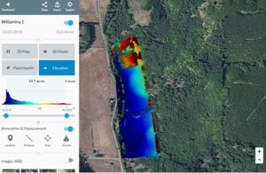
- PPlant Health
- PPoint Cloud
- P Orthomosaic
- P 3D Models
- PShare & Export
- PTopographical Data
- P Click and Drag Viewing
- PElevation Maps
Our great Visual Map just got better:
Now with Plant Health and Elevation!
